question about Asia/Urumqi: why Guangdong

In the commentary for zone Asia/Urumqi one reads # Xin-zang Time ("Xinjiang-Tibet Time") # The Gansu counties Aksay, Anxi, Dunhuang, Subei; west Qinghai; # the Guangdong counties Xuwen, Haikang, Suixi, Lianjiang, # Zhanjiang, Wuchuan, Huazhou, Gaozhou, Maoming, Dianbai, and Xinyi; # east Tibet, including Lhasa, Chamdo, Shigaise, Jimsar, Shawan and Hutubi; # east Xinjiang, including Urumqi, Turpan, Karamay, Korla, Minfeng, Jinghe, # Wusu, Qiemo, Xinyan, Wulanwusu, Jinghe, Yumin, Tacheng, Tuoli, Emin, # Shihezi, Changji, Yanqi, Heshuo, Tuokexun, Tulufan, Shanshan, Hami, # Fukang, Kuitun, Kumukuli, Miquan, Qitai, and Turfan. Question: what is the rationale for having the Guangdong counties listed for this zone? Guangdong is the province around Hongkong, with latitude around 20n and longitude around 115e. This is geographically very far away from east Tibet and east Xinjiang, altitude around 40n and loangitude less than 82e. What is the source for listing Guangdong here? I presume that this is an error.
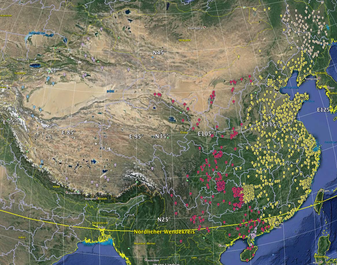
PS: I have to add: The inclusion on the south-east Guangdong counties with Asia/Urumqi comes from the Shanks data, but I still wonder what evidence exists for this oddity. I attach a visualization with Google maps, having used only those towns from geonames.org which have one of the China zones, plus a non-zero population figure. Asia/Chongqing red, label 4 Asia/Harbin gey, label 1 Asia/Kashgar light blue, label 5 Asia/Shanghai yellow, label 3 Asia/Urumqi light violet, label 2 I also attach the kmz file which can be opened with Google Maps. On 02.02.14 18:42, Alois Treindl wrote:
In the commentary for zone Asia/Urumqi one reads
# Xin-zang Time ("Xinjiang-Tibet Time") # The Gansu counties Aksay, Anxi, Dunhuang, Subei; west Qinghai; # the Guangdong counties Xuwen, Haikang, Suixi, Lianjiang, # Zhanjiang, Wuchuan, Huazhou, Gaozhou, Maoming, Dianbai, and Xinyi; # east Tibet, including Lhasa, Chamdo, Shigaise, Jimsar, Shawan and Hutubi; # east Xinjiang, including Urumqi, Turpan, Karamay, Korla, Minfeng, Jinghe, # Wusu, Qiemo, Xinyan, Wulanwusu, Jinghe, Yumin, Tacheng, Tuoli, Emin, # Shihezi, Changji, Yanqi, Heshuo, Tuokexun, Tulufan, Shanshan, Hami, # Fukang, Kuitun, Kumukuli, Miquan, Qitai, and Turfan.
Question: what is the rationale for having the Guangdong counties listed for this zone?
Guangdong is the province around Hongkong, with latitude around 20n and longitude around 115e.
This is geographically very far away from east Tibet and east Xinjiang, altitude around 40n and loangitude less than 82e.
What is the source for listing Guangdong here? I presume that this is an error.

Alois Treindl wrote:
what is the rationale for having the Guangdong counties listed for this zone?
It's the comment labeled "From Jesper Norgaard Welen (2006-07-14)" in that file. For more details, please see the email archives around that time, e.g.: http://mm.icann.org/pipermail/tz/2006-July/013704.html
Paul, that email refers to www.astro.com/atlas, which is my own website. We use data from the Shanks atlas on the current atlas feature. I know that Shanks has this division of Guangdong into three parts, and I wonder whether there is any OTHER source saying the same thing. On 02.02.14 21:55, Paul Eggert wrote:
Alois Treindl wrote:
what is the rationale for having the Guangdong counties listed for this zone?
It's the comment labeled "From Jesper Norgaard Welen (2006-07-14)" in that file. For more details, please see the email archives around that time, e.g.:
participants (2)
-
 Alois Treindl
 -
 Paul Eggert